Live in our Community
Bullhead City ~ Fort Mohave ~ Mohave Valley
Bullhead City
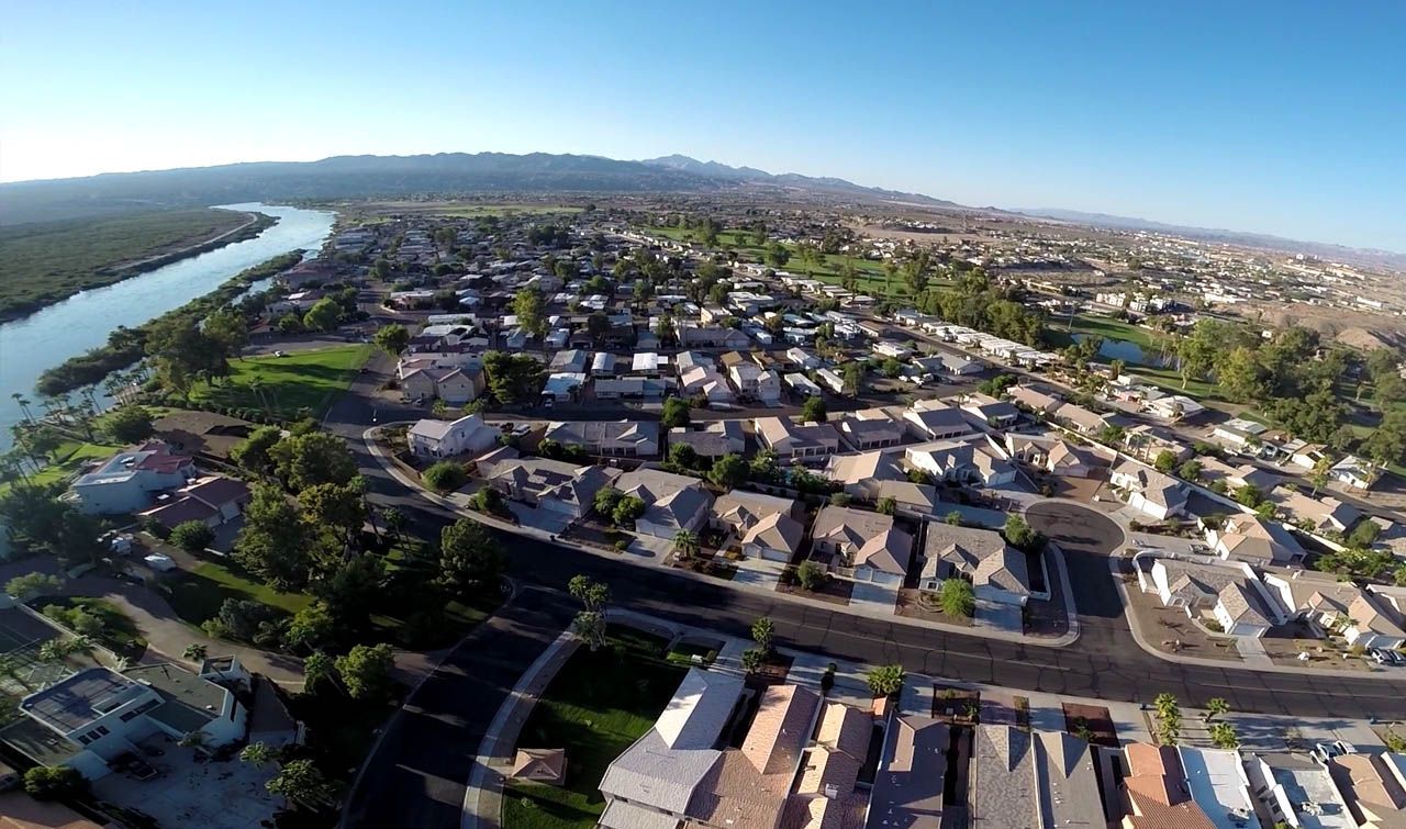
A family-oriented, vibrant community providing residents and businesses careful growth, environmental awareness, and an affordable place to live with a high quality of life. In addition to qualities of life, there are approximately two-million visitors per year that frequent Bullhead and its sister city and the popular gaming community of Laughlin, Nevada.Today, tourism continues to be a primary economic activity derived from the Laughlin resort/gaming industry, area water sports, golf, fishing, senior and youth sporting events. Thousands of winter visitors travel to this area for the desert weather to enjoy more than 300 sunny days a year.
Bullhead City has also been referred to as Arizona‘s West Coast because the City is located on the east bank of the Colorado River near the juncture of Arizona, California and Nevada. Bullhead City serves as the economic hub and retail shopping center for Western Mohave County and Southeastern Clark County, Nevada. It’s easily accessible by major highways and is a short drive from Los Angeles, Phoenix and Las Vegas.
HISTORY OF BULLHEAD CITY
The modern beginnings of Bullhead city were revived with the construction of Davis Dam, which broke ground in 1942. Construction of the Dam was brought to a halt due to World War II and the need for necessary construction materials. Construction resumed in 1946, a year after the war ended, and the dam was completed in 1950, which impounds Lake Mohave in the Lake Mead National Recreation Area. The dam is named after the late Arthur Powell Davis, Director of the U.S. Bureau of Reclamation from 1914 until 1923.
Construction workers on the project lived with their families at the foot of the dam in a community called Davis Camp. Nearby, a town sprung up from the remains of Hardyville to support the growing population. The town was named Bullhead City after a rock island in the Colorado River that resembled the head and shoulders of a bull with large, curved horns. The Bullhead City post office was established in 1946, and the rock was submerged under the rising water of Lake Mohave as it backed up behind Davis Dam in the early 1950s.
In the 1960s developers began advertising local subdivisions in Southern California, and the retirement population began to grow. The City’s population has grown from just over 10,000 residents in 1980 to more than 40,000, according to the 2010 Census.
The City of Bullhead City incorporated on August 28, 1984 and became Arizona’s 77th municipality. As of 2021, Bullhead City is approximately 60.15 square miles.

Fort Mohave
Fort Mohave is a CDP in Mohave County, Arizona. It is named for a nearby fort that was used during the Mohave War. As of the census of 2010, the population of Fort Mohave was 14,364. This was up from 8,919 in 2000. It is a micro-suburb of Bullhead City. Its recent growth has made it the most populous unincorporated community in Mohave County.
Fort Mohave is home to Valley View Medical Center, which opened in 2005. It is a 102,000-square-foot (9,500 m2) facility with state-of-the-art technology. The hospital features 38 medical/surgical beds, 10 rehabilitation beds, a six-bed labor and delivery unit, a six-bed intensive care unit, four major operating rooms and two procedure rooms. In 2010, Valley View announced a 1.2 million Emergency Room expansion
Fort Mohave is home to the Fort Mojave-Mesa Fire Department. It is also home to the largest stadium within 90 miles (140 km), serving all Mohave County for large indoor events, The Mojave Crossing Event Center. It has a seating capacity of 3,000 stadium style and 5,000 arena style.
Many neighborhoods in Fort Mohave are built on man-made lakes, golf courses, and mesas with majestic mountain views. The newest golf course, LosLagos GolfClub, is a Ted Robinson, Sr. Signature Golf Course.
Fort Mohave has two public elementary schools, Fort Mojave Elementary School and Camp Mohave Elementary School, both of which are a part of the Mohave Valley Elementary School District
Fort Mohave has two large grocery stores, Smith’s Food and Drug and Safeway. It also has a CVS Pharmacy and an ACE Hardware Store. Restaurants include Red Dragon Chinese Cuisine, Bonanza Cafe, Casa Serrano Mexican Food, an ice cream parlor, and several fast food franchises. Residents of Fort Mohave do the majority of their shopping and dining in Bullhead City, which is considered the shopping hub of the tri-state area. Wal-Mart has plans to build a 155,000 sq. ft. supercenter on HWY 95 between Hammer Ln and Teller Rd in Fort Mohave.
Fort Mohave is also serves as a prime location for future Industrial Growth in Mohave County. The Mohave Tri-State Business Park currently has 132 fully improved/shovel ready acres of Industrial land ready for develop. The location places industry less than 5 hours from over 8 million potential customers.Click here for drive time map from The Mohave Tri-State Business Park. Current tenant at the Mohave Tri-State Park Include the
Freeman Regional Distribution Center.
Want more info?
Mohave Valley
Is a small valley mostly on the east shore of the south-flowing Colorado River. The valley is in southwest Mohave County, Aizona and is a region at the intersection of the southeast Mohave Mojave and northwest Sonoran Deserts. The valley borders southeast California San Bernardino County; also, the north of the valley borders extreme southeast Clark County, Nevada.
Want more info?

Oatman
“Wild Burro’s panhandling, gunfighters shooting and ladies dressed in 1890’s style strolling, it must be Oatman, Arizona. Just across the Colorado River and up the hill from Laughlin, Nevada on Historic Route 66 is the lively gold mining town of Oatman. In its heyday of the early 1900’s to the 1940’s, Oatman and its two mile away companion town of Goldroad were the largest producers of gold in Arizona.
During the Second World War the government needed other metals for the war effort, so the miners were taken to other mines and the mines here closed. The gold was just waiting for better times. Then in 1995 the Goldroad mine was opened again and was taking out 40,000 oz. of gold annually. In 1998 they closed again because of low gold prices. They now have great mine tours daily.
In 1952, Route 66, the main route from the Midwest to California, bypassed this stretch of mountains to be I-40 from Kingman, Arizona to Needles, California. Oatman and Goldroad became real Ghost Towns.
In the 70’s Laughlin, Nevada started building up and in the late 80’s Route 66 became popular destination for tourists from all over the world. Oatman started becoming very lively again.
Oatman’s “Wild” Burro’s are the descendants of burro’s brought here by the miners and when no longer needed were turned loose. They wander the streets and greet our tourists. We usually have about ten burro’s and a few babies.
The Oatman Ghost Riders Gunfighters perform Wild West Shootouts every day at 1:30 pm and 3:30 pm (the 3:30 pm show may not be performed during summer months due to heat and amount of tourists) and are available for “Shotgun Weddings”, Tour Bus “Robberies”, Stage Coach Hold Ups they like to call them that, and all kinds of special gunfight shows. Also the Oatman Ghost Rider Gunfighters are available for School Field Trips along with Jackie from Fast Fanny’s, Prospector Bob and Billy Bob Bob. So come watch the Ghost Rider Gunfighters with some downright Funny Old Wild West Comedy!
We have about 40 gift, antique, and craft shops, 2 Old Time Photo Shops with one that does custom sign painting, Judy’s Bar, assorted ghosts and several places to eat and listen to live music. They include The historic Oatman Hotel with its thousands of dollar bills tacked to the walls of the restaurant and bar and the Olive Oatman Restaurant and Ice Cream Saloon that is named for and sports a large painting of Olive Oatman who in 1851 was captured by Indians and was later traded to the local Mohave Tribe, where she spent 3 years before being returned to her family.
Some of our fun town events are the Bed Races in January (check out our Events Page), the Sidewalk Egg Fry Contest on the 4th of July, Gold Camp Days with the International Burro Bisket Toss on Labor Day weekend and the Book Fair and Bake Sale on Veterans Day weekend in November. Special holiday events on Easter, Halloween, Memorial Day, and of course Christmas times are also great Entertainment. See our EVENTS page.
Want more info?
Lake Havasu City
Lake Havasu City, home of the historic London Bridge, is situated on the Arizona shore of Lake Havasu on the Colorado River border with California.
In 1963, Robert P. McCulloch flew over the region and became inspired to begin establishing a self-sufficient planned community. After hearing the London Bridge spanning the River Thames in London was up for auction, McCulloch placed the winning $2,460,000 bid in 1968. Including purchase, the cost of dismantling, shipping, and reconstructing the bridge from England to a desert peninsula on Lake Havasu reached $7 million.
The Bridgewater Channel was excavated under the bridge to allow for flowing water and an English Village replication was adjacently constructed prior to the official London Bridge dedication in October 1971. The London Bridge is now known as the largest antique in the world.
Lake Havasu City, located in Mohave County, was officially incorporated in 1978 and encompasses 42 square miles and a year-round population of about 54,000. Only Arizona Highway 95 runs through Lake Havasu City, which is 18 miles south of Interstate 40 and 65 miles north of Interstate 10.
As Arizona’s Playground, visitors are attracted to the friendly community year-round. The summer months provide plenty of on-the-water fun with beach bathing, swimming, paddle sports, and watercraft exploration of 60 miles of navigable waterways. In 2017, Bassmasters ranked Lake Havasu as the 8th best bass fishing lake in the Western United States; the lake is known for its largemouth and smallmouth bass, striped bass, bluegill, redear sunfish, channel catfish, flathead catfish, and crappies. Formed by Parker Dam, Lake Havasu offers 400 miles of shoreline along its deep blue-green waters and 300 days of year-round sunshine.
The surrounding Mohave desert turns into an off-road playground during the winter months with an extensive network of more than 1,800 miles of trails for off-road adventures in all-terrain vehicles or by hiking. Early mines and mining towns are scattered in the desert to the north and east of the City. For those interested in geological phenomena, within a ten-mile radius of Lake Havasu City, specimens such as volcanic rock, geodes, jaspers, obsidian, turquoise, and agate can be uncovered. The annual event calendar is filled with 400 events including the annual hot air Balloon Festival, Winter Blast firework show, Bluegrass festival, high-performance boat races, classic car shows, and boat regattas.
To add to the quaintness of the lake community, Lake Havasu is home to more replica lighthouses than any other city in the U.S. Twenty-six smaller-scale versions of functioning navigational aids have been built to the specifications of famous east and west coast lighthouses.
Lake Havasu City offers a broad range of community facilities including an airport, a historical museum, the largest sports park in Arizona, a 1,100-acre recreational park, dog parks, an aquatic center, athletic fields, and biking and walking paths. The community also highlights its Main Street experience in the Downtown District, its shops along the Bridgewater Channel, The Shops at Lake Havasu, as well as an extensive variety of local culinary menus and award-winning breweries.
To plan your trip, go to www.golakehavasu.com
Kingman
The City of Kingman is the County seat of Mohave County located in northwest Arizona along Interstate 40 and U.S. 93. Kingman elevations range from 3,300 to 3,800 feet. The city straddles the scenic Hualapai, Cerbat and Black Mountains, which offer hiking, picnicking, camping, and other outdoor activities in the cool pines.
The Kingman and Colorado River areas offer a unique range of recreational and historical attractions as do several ghost towns in the area. The rivers and lakes offer fishing along with boating and other forms of water-oriented recreation. Kingman is an easy commute to Las Vegas, Laughlin, Phoenix and the Grand Canyon or a half day’s drive to Los Angeles or San Diego. Kingman is known for being along the longest remaining preserved stretch of Historic Route 66. Known as an all American highway, Kingman’s stretch of this historic route recently received national recognition as a National Scenic Byway. Visitors from all over the globe visit Kingman to get their “Kicks on Historic Route 66.”
Kingman continues to grow in its importance as a regional trade, service and distribution center for northwestern Arizona and the Western United States. Growth in U.S. trade with Canada and Mexico, combined with the city’s strategic location on national transportation routes, continues to provide an excellent opportunity for Kingman to be a center for international trade. Major transportation modes serving Kingman include I-40, U.S. 93 (soon to be Interstate 11), two BNSF main lines, and a commercial airport offering one-day access to ALL major southwest markets. Interstate 40 provides immediate east-west access from California to the east coast. U.S. 93 (soon to be Interstate 11) is widely known to be a part of the CANAMEX Corridor providing north-south trade access from Canada into Mexico.
Between 1990 and 2000, the city’s population increased by over 57%, from approximately 13,208 to 20,069. The city estimates its current population is 26,000+ and is expected to continue to grow at a rapid pace. At the border of Kingman’s city limits is an unincorporated area with an estimated population of 17,000. As the city continues to attract additional new residents each month and new businesses each year, a great demand for new products and services makes Kingman an ideal place for exciting new opportunities.
Kingman’s quality housing, excellent schools including community college with extended learning through Northern Arizona University, low crime rate, clean environment, several parks, 2 public golf courses, regional attractions, available land and natural resources, and the pleasant climate are just a few of the many positive factors that have attracted new residents and businesses to Kingman.


